Soil Water – Methods to Predict Plant Available Water Capacity (PAWC) Using Soil-Landscape Associations
Farm Table says:
The authors of this paper note in the conclusion: 'The eSPADE tool also includes predictions of electrical conductivity (EC), which is an important indicator for subsoil salinity. This can be used to identify areas where the risk of subsoil salinity reducing PAWC may be higher.' Please access the full paper via the link below if this research interests you
The take home messages from this GRDC funded research are below. Please access the full paper via the link below for methodology, references, acknowledgements and discussion.
Take home messages from the paper include:
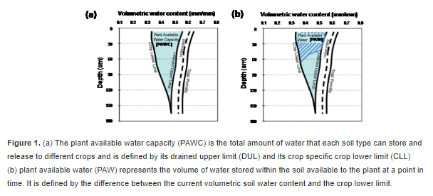
- Plant available water (PAW) is a key determinant of potential yield in dryland agriculture. Obtaining a measurement or estimate of PAW can, therefore, inform cropping decisions relating to time of sowing, crop type or the level of fertiliser inputs.
- Estimating PAW, whether through soil coring, use of a soil water monitoring device or a push probe, requires knowledge of the plant available water capacity (PAWC) of a soil. PAWC characterisations for 26 Soil Management in the Liverpool Plains are publicly available in the APSoil database, which can be viewed in Google Earth and in the SoilMapp application for iPad.
- PAWC for wheat within the Liverpool Plains range from 115 to 300 mm. PAWC for other crops may be similar (e.g. sorghum, cotton) or less (e.g. chickpea, mungbean). Variation in the observed PAWC can be linked to parent material, texture and subsoil constraints, with subsoil salinity responsible for the largest reductions in PAWC.
- Similarity in soil properties is key when extrapolating from these PAWC characterisation sites to a location of interest – the nearest characterisation is not necessarily the appropriate one.
- Conceptual models of relationships between soil properties, parent material and position in the landscape can assist with extrapolation and prediction of PAWC. This information is increasingly becoming available on-line, including soil-landscape and soil and land resources mapping of the Liverpool Plains on eSPADE.
- Digital maps of predicted soil properties at 90 or 100 m resolution are also being developed and can assist with identifying areas where the risk of subsoil salinity reducing PAWC needs to be considered.
- Work is currently underway to test and refine the PAWC prediction processes and make them more user-friendly.
- In the meantime, exploring the soil differences on your farm using these tools and the provided PAWC information may explain differences in performance between or within paddocks, help adjust yield expectations and inform management decisions.
